Te Utanganui Central New Zealand Distribution Hub
Te Utanganui is a freight, logistics, and distribution hub that cements the role of Palmerston North and Manawatū as an integral part of New Zealand’s national and international trade networks.
Manawatū is the natural and logical centre for distribution across central New Zealand and sits at the intersection of State Highways 1, 2 and 3, enabling easy connections to Wellington, Wairarapa, Hawke’s Bay and Taranaki. It also includes:
- Palmerston North Airport, which is one of only three key airports in New Zealand that can move freight 24/7
- the planned KiwiRail Regional Freight Hub that will generate significant freight distribution opportunities for Te Utanganui
- the proposed Manawatū regional freight ring road that would make freight movement around and to the city more efficient.
The name Te Utanganui was gifted by Rangitāne o Manawatū and invokes the concept of an inland port, and where things of value arrive by sea, sky and land, and then flow outwards again. Ki uta refers to an inland location and nui describes the hub’s vastness and importance.
Read more about the story and strategy for Te Utanganui on the CEDA website
What’s planned for Te Utanganui
To unlock the economic potential of Te Utanganui, additional land must be zoned for industrial growth. A high-level masterplan was adopted in mid-2024 to guide future land-use and infrastructure planning for the area.
Delivering on the masterplan is a collaborative approach across road, rail, and air transport projects, rezoning and community planning. More detailed assessments will be conducted for realising each part of the masterplan.
When planning for future housing, business, and industrial growth, we need to think 30 years ahead. You’ll see how Te Utanganui fits into the whole district’s 30-year growth story in our Future Development Strategy.
A key feature of this strategy is consolidating industrial areas around key transport routes and hubs.
You can view the details of the plan by clicking on the map below.
 (JPG, 470KB)
Proposed timeframes for development
Development for Te Utanganui will require significant infrastructure investment, including work on the North Island Main Trunk Railway Line, integrated stormwater reserves, and a regional freight ring road to support the freight hub's operation. Some of this infrastructure will be designated and constructed by us to unlock each stage, and some will be delivered by or in partnership with others such as KiwiRail, NZ Transport Agency - Waka Kotahi, and private developers.
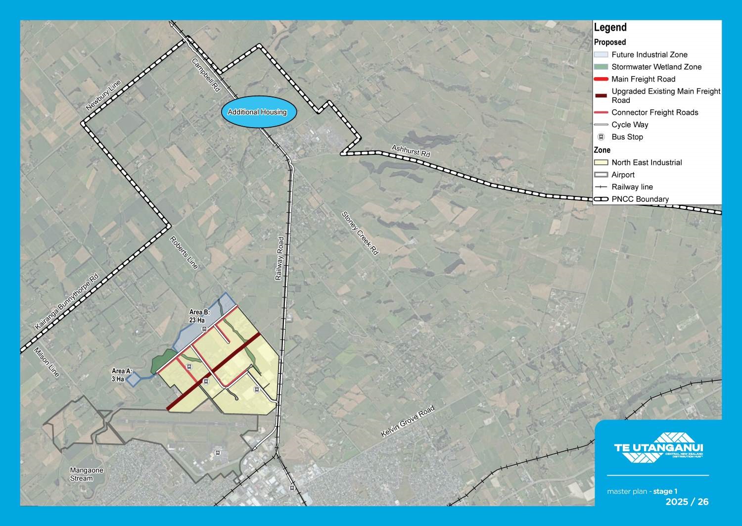
Expanding the North East Industrial Zone will be investigated in 2 stages, eventually covering a total area of 176 hectares by 2052, with development of the KiwiRail freight hub playing a pivotal role.
North East Industrial Zone expansion: 2025/26
The first 26 hectares of land to be developed will include 3 hectares (Area A) and 23 hectares (Area B) with a supporting stormwater management reserve.
Additional sites at 105,109, and 129 Richardsons Line and 813 and 815 Roberts Line will be included subject to an assessment of flood and lateral spread risk.
The following infrastructure will facilitate this industrial development:
- The extension of Aldersons Drive from the existing North East Industrial Zone to Richardsons Line, negotiated through a development agreement;
- A central stormwater reserve, new road connecting Areas A and B, and associated three waters infrastructure has yet to be funded.
- Water, wastewater, and roading upgrades have already been extended along Richardsons and Setters Lines to prepare for this rezoning.
- Upgrades to Roberts Line and safety improvements at Milson/Richardsons Lines have been planned to start in 2026/27.
- Powerco have a new 33kv circuit and substation planned to start in 2026/27.
Timeline for Draft Plan Change N: Te Utanganui – North East Industrial Zone Areas A & B:
- Prepare rezoning proposal: Now until Oct 2025
- Public consultation: Late 2025/early 2026
- Public Hearings: Mid-2026
- Decision: Late-2026
- Appeals: Early 2027
- Rezoning made operative: Mid-2027
This project will overlap with investigations to confirm the route for the Manawatū Regional Freight Ring Road and the development of the Bunnythorpe Community Plan.
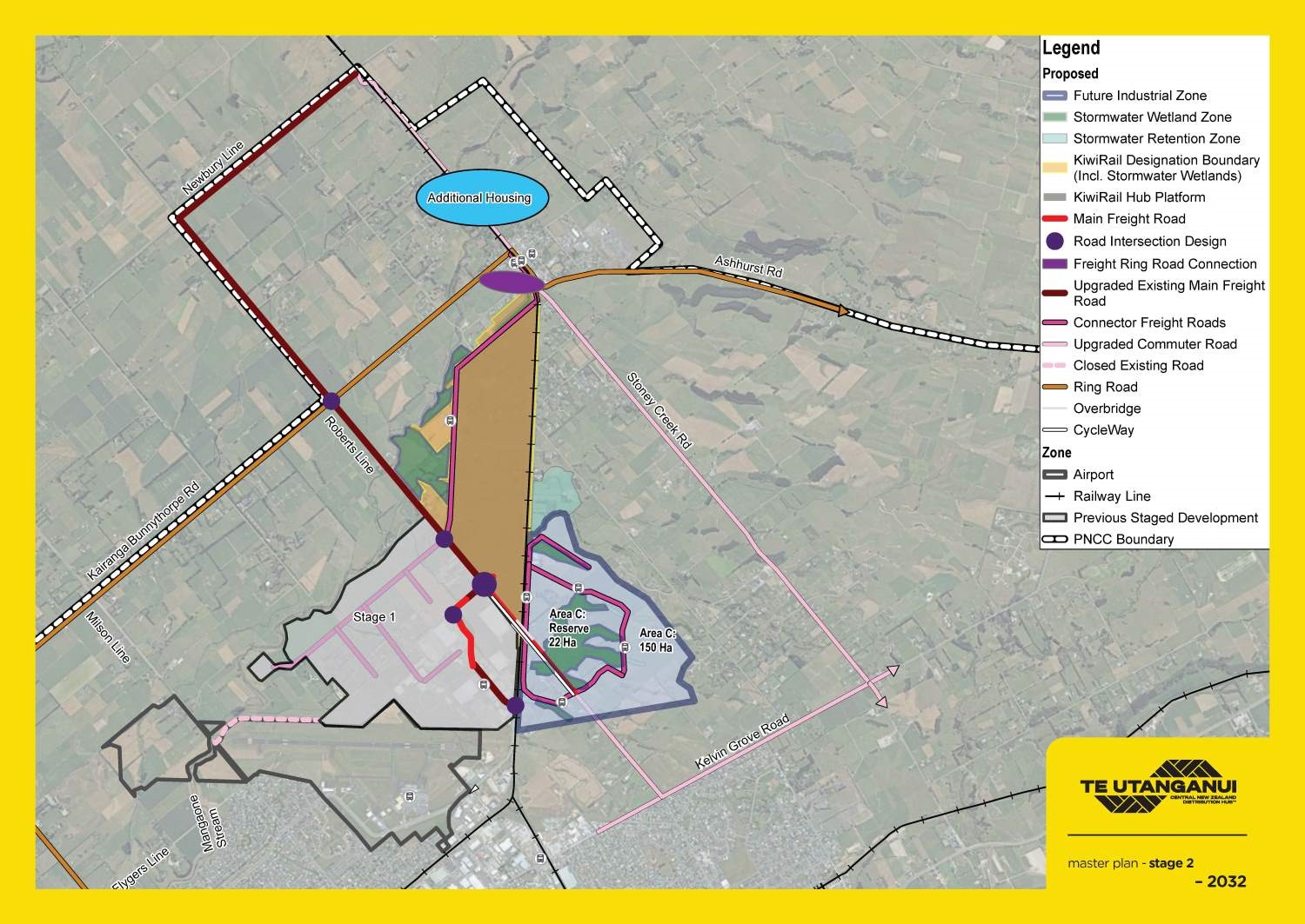
Railway Road industrial zone expansion: 2032 onwards
Area C includes a further 150 hectares of land located to the east of Railway Road to time with the development of the KiwiRail freight hub. Investigations to rezone Area C may start as early as 2027 to meet demand for industrial land by 2032.
This stage requires significant infrastructure investment in the form of an overbridge at Railway Road and Roberts Line before any development, so that it can connect safely to the KiwiRail freight hub, airport, and regional freight ring road. It will also need 22 hectares of land for a central stormwater/amenity/ecological reserve which would likely need to be purchased and developed by us.
This area has more challenging topography, existing land use, and sensitive boundaries with lifestyle blocks to the east and the air navigation radar to the south.
This project will overlap with the development of the Kiwirail Regional Freight Hub and a possible private plan change for the Bunnythorpe Business Park (corner of Kairanga-Bunnythorpe Road and Roberts Line).
Improving our road network will be an important part of this work
A regional freight ring road is required to enable the efficient operation of a freight hub of the proposed scale, to avoid further impacts of heavy vehicle use on the city’s urban network, and to provide safe connections to and from Bunnythorpe village.
Council and NZ Transport Agency - Waka Kotahi have a partnership called the Palmerston North Integrated Transport Initiative, which will see about 70 transport projects occur in the city over the coming 30 years. These projects are aimed at improving safety in our urban areas, and helping freight move around more efficiently around the city rather than using suburban roads.
More investigations are needed to confirm each stage of the masterplan
This masterplan is a high-level vision at this stage. More detailed investigations into flood risk, stormwater servicing, transport upgrades, noise effects, landscape issues and high class soils will be needed to support rezoning for each stage through a public District Plan change process.
Technical reports
These are the technical assessments that have informed the masterplan to date:
Te Utanganui Masterplan Report(PDF, 3MB)
Constraints Maps(PDF, 504KB)
Cultural Impact Assessment(PDF, 707KB)
Industrial and Housing Land Forecast(PDF, 267KB)
Noise Assessment(PDF, 384KB)
Rail Assessment(PDF, 552KB)
Railway Road and Roberts Line Transport Assessment(PDF, 7MB)
Review of Previous Work Completed(PDF, 997KB)
Stormwater Assessment(PDF, 5MB)
Transport Assessment(PDF, 641KB)
The masterplan was discussed by Council's economic growth committee on 21 June 2023.
We’ll keep you informed every step of the way
As the project progresses, we’ll be working with those affected by the proposed changes and our community every step of the way. We’ve begun talking to landowners within the planned zone and other interested parties.
In April 2024 we sought submissions on the masterplan through public consultation on the Future Development Strategy and the Long-Term Plan 2024-34. Now community feedback has helped to shape the masterplan, we'll begin designing a proposed change to our District Plan. We expect to have this ready for consultation by 2026.
There will be more opportunities to have your say as each stage of the plan progresses.